Harnessing Agri Stack, Krishi-DSS, and soil mapping to make farming smarter and more sustainable.

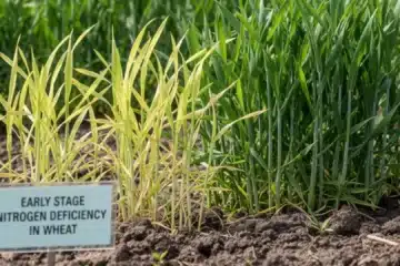
Farmers often struggle with late advisories, unpredictable weather, and limited access to scientific insights. At Krishi GK, we bridge this gap by tapping into India’s Digital Agriculture Mission. Through tools like Agri Stack and the Krishi Decision Support System (DSS), we integrate satellite data, weather patterns, and soil health indicators to deliver timely, farmer-friendly advisories.
With soil profile mapping and Digital Public Infrastructure (DPI), Krishi GK empowers farmers to decide what to sow, when to irrigate, and how to maximize yields sustainably. We ensure that satellite-backed insights reach even the most remote farmer—not just policymakers.
Our field partners conduct hands-on training sessions where farmers learn to read simple soil-health cards and understand advisories in their own language. We convert complex space-data models into easy WhatsApp messages, voice alerts, and community meetings, ensuring inclusivity even for farmers who aren’t digitally literate. Looking ahead, Krishi GK is working on integrating drone-based crop health imaging with farmer decision-making. This means a farmer will know in advance whether their field is stressed, how much fertilizer is required, and whether pest infestation is likely—all before damage spreads. This is the true power of space meeting soil.